
Postdoctoral Research Associate Noli Brazil led the research team. (Photo/Mike Glier)
USC spatial sciences students analyze crime patterns in L.A.
Using location-based data, researchers show where violent crimes are concentrated and how that information can lead to positive results
When the mayor of Los Angeles considers the potential of your research on crime data and public safety so valuable that he invites you to work with his team, it’s quite exciting — especially if you’re an undergraduate.
Students and researchers from USC’s Spatial Sciences Institute recently presented their work to members of Mayor Eric Garcetti’s data team and the Los Angeles Police Department. Their project, “A Spatial Analysis of Street-level Crime Trends in Los Angeles,” started last fall.
Postdoctoral research associate Noli Brazil and Geographic Information System (GIS) project specialist Beau MacDonald were among the researchers.
Using data from GeoHub — Los Angeles’ new public platform for exploring and visualizing location-based open data — the student researchers created a mapping application that brought together data about crime occurrences with social and built-environment characteristics by incorporating variables like unemployment rates, the presence or absence of street lights and proximity to metro rail and bus stops. The team then examined this visualized data as it applies to specific street segments.
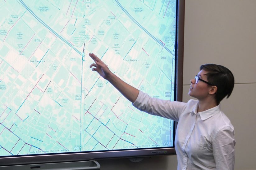
In the presentation, the SSI team shared its analysis, which underscored the importance of connecting place and space to improve public safety and demonstrated how the mapping application can uncover patterns of crime. This street segment approach could help city leaders understand where and when crime is actually occurring so that civic resources, such as patrol units or street lighting, could be used more effectively.
For example, if the number of crime incidents reported in one location from one year to another remained constant, one might conclude that there has not been an increase nor a decrease in crime there. Using the analytical tools of the USC mapping application, however, viewers can see patterns of the particular times of days and days in the week when and where the types of crime are occurring, set in the context of street information, such as the presence of a school, park, community center or liquor store. With this more specific information in hand, law enforcement and community services could tailor the deployment of their resources to reduce crime.
Community safety
Presentation attendees included Lilian Coral, chief data officer for Garcetti; Sari Ladin, data fellow for the mayor; Brian Buchner, the mayor’s policy director for public safety; and Arnold Suzukamo, a GIS specialist with the LAPD.
Their mapping application is an important addition to our toolbox that directly supports the mayor’s emphasis on making data-driven decisions.
Brian Buchner
“We were so impressed with the high quality of work that the Spatial Sciences Institute has done. They have brought us an innovative approach that will be tremendously useful as the mayor’s office, LAPD and other city stakeholders work to develop policies and strategies to improve community safety,” Buchner said. “Their mapping application is an important addition to our toolbox that directly supports the mayor’s emphasis on making data-driven decisions, and we are looking forward to continuing our work with SSI, its faculty and students.”
Coral was pleased to partner with USC on the project.
“We were looking to test a partnership that mirrored the pace of City Hall and brought the talents and skills of academic staff and students to timely and urgent city challenges like crime,” she said.
“The results have been immensely valuable in providing lessons for how to work with academic institutions to drive real value out of the partnership. They’ve also been eye-opening and innovative in lending a new lens to evaluating crime density and changing trends.”
Personal accomplishments
Student researchers included undergraduates Izzy Mitchell, Richard Windisch, Kyra Schoonover, Robin Franke, Leonard Ngo and spatial informatics master’s student Yuqing Qian. The students were funded by a donation from GIS company Esri, which was a partner with the city of Los Angeles in constructing the GeoHub portal. The students worked under the direction of Brazil, MacDonald and SSI Director John Wilson.
Windisch, an L.A. native, is a junior majoring in GeoDesign at the USC Dornsife College of Letters, Arts and Sciences. He relished putting his curriculum-based learning into practice through this project.
“The opportunity to be on this research team and present a semester’s worth of research to city officials and partners was a unique experience and personal accomplishment,” he said. “I was able to see the importance of my degree in spatial sciences and how it can benefit an entire city as well as improve the understanding of Los Angeles’ working parts through the lens of different city departments.”
Windisch is enthusiastic about the potential of data troves like L.A. GeoHub to help cities run more smoothly.
“I truly envision the L.A. GeoHub opening a door to better understand spatio-temporal patterns in crime occurrence, support the ability to better deploy city resources and make policy changes that improve public safety.”
Mitchell, a senior majoring in GeoDesign and minoring in architecture, agreed that the project has been a rewarding learning experience that complements the research theory from her major. After graduating this spring, she plans to work in urban design to learn more about the workings and processes of the built environment.
“Ultimately, I hope to work on projects that integrate GIS into more aspects of how cities are managed and used,” she said. “That is partly why this research project in particular was so interesting to me; I see it as an opportunity not only to provide information to City Hall and LAPD about crime trends, but also to create a mapping application that they can continue to use to better inform policing and policymaking.”
Getting the opportunity to present her research to L.A. city professionals and respond to their questions and critique was invaluable in helping her move forward in her goal of creating useful information systems for urban planning and design purposes, Mitchell said.
“Rich and I are excited to continue working on this project in the spring semester.”